![]()
![]()
Welcome to geonum
GitHub: https://github.com/jgliss/geonum
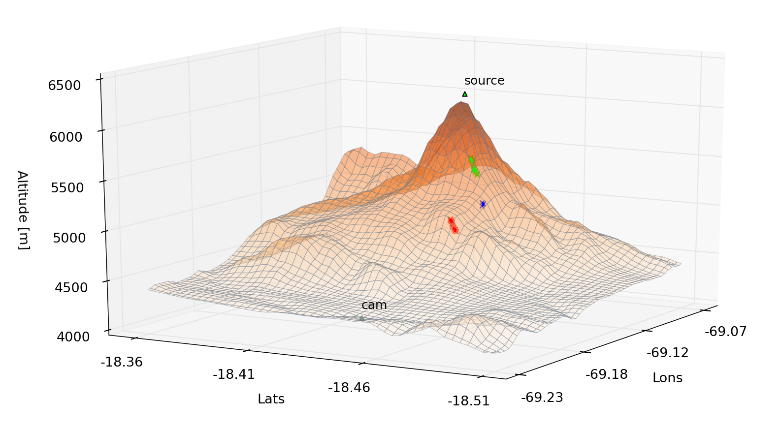
Automatic retrieval of topographic distances (example showing Guallatiri volcano, Chile)
Contents:
- Introduction
- Installation
- Example scripts
- Tutorials gallery
- API Reference
- Specifying locations on Earth
GeoPointGeoPoint.altitudeGeoPoint.altitude_errGeoPoint.local_topo_pathGeoPoint.longitudeGeoPoint.latitudeGeoPoint.offset()GeoPoint.set_topo_data()GeoPoint.range_borders()GeoPoint.get_topo_data()GeoPoint.check_topo()GeoPoint.get_elevation_profile()GeoPoint.set_topo_altitude()GeoPoint.plot_2d()GeoPoint.plot_3d()GeoPoint.type()GeoPoint.from_LatLon()
- Connecting the dots
GeoVector3DGeoVector3D.dxGeoVector3D.dyGeoVector3D.dzGeoVector3D.nameGeoVector3D.dz_kmGeoVector3D.azimuthGeoVector3D.elevationGeoVector3D.polar_angleGeoVector3D.magnitudeGeoVector3D.normGeoVector3D.dist_horGeoVector3D.anchorGeoVector3D.set_anchor()GeoVector3D.intersect_hor()GeoVector3D.plot()GeoVector3D.type()
- Working with geographical domains
GeoSetupGeoSetup.idGeoSetup.pointsGeoSetup.vectorsGeoSetup.llGeoSetup.trGeoSetup.lon_llGeoSetup.lat_llGeoSetup.lon_trGeoSetup.lat_trGeoSetup.delta_lonGeoSetup.delta_latGeoSetup.borders_setGeoSetup.center_coordinatesGeoSetup.magnitudeGeoSetup.topo_accessGeoSetup.cmap_vecsGeoSetup.has_points()GeoSetup.has_topo_data()GeoSetup.set_local_topo_path()GeoSetup.change_topo_mode()GeoSetup.get_topo()GeoSetup.load_topo_data()GeoSetup.has_point()GeoSetup.has_vector()GeoSetup.contains_coordinate()GeoSetup.add_geo_point()GeoSetup.add_geo_points()GeoSetup.add_geo_vector()GeoSetup.add_geo_vectors()GeoSetup.delete_geo_point()GeoSetup.delete_geo_vector()GeoSetup.new_geo_point()GeoSetup.set_borders_from_points()GeoSetup.points_close()GeoSetup.create_test_setup()GeoSetup.create_map()GeoSetup.plot_2d()GeoSetup.plot_3d()
- Computing elevation profiles
ElevationProfileElevationProfile.observerElevationProfile.endpointElevationProfile.topo_dataElevationProfile.lineElevationProfile.observer_topogridElevationProfile.endpoint_topogridElevationProfile.dist_horElevationProfile.azimuthElevationProfile.profileElevationProfile.distsElevationProfile.resolutionElevationProfile.gradientElevationProfile.slopeElevationProfile.minElevationProfile.maxElevationProfile.alt_rangeElevationProfile.slope_angles()ElevationProfile.slope_angle()ElevationProfile.det_profile()ElevationProfile.get_altitudes_view_dir()ElevationProfile.get_first_intersection()ElevationProfile.find_horizon_elev()ElevationProfile.get_altitude_at_distance()ElevationProfile.plot()
- Further tools
- Topographic data
- Atmospheric calculations
- Helper methods
- Utility functions
- Plotting
- Custom exceptions
- Specifying locations on Earth
- Upcoming changes
- Contribute